
CNN
—
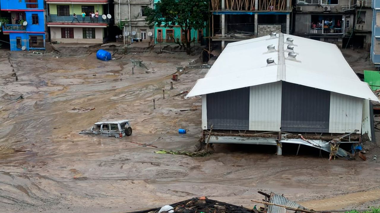
More than 100 people are missing in India’s northeast after heavy rain caused a glacial lake to burst, leading to flash floods which ripped through the Himalayan state of Sikkim Wednesday, killing at least 19 and washing away roads and bridges, according to the state government.
A “sudden cloudburst” over Lhonak Lake, in the northern part of the state, sent fast-moving torrents of water surging down the Teesta River in Sikkim’s Lachen valley, raising water levels 15-20 feet higher than normal, the Indian Army said in a statement. A cloudburst is a very sudden and destructive rainstorm.
Chungthang Dam, also known as the Teesta 3 dam and part of a major hydropower project in the state, was “washed away,” according to a statement issued by the National Disaster Management Authority on Wednesday night.
Drinking water supplies and sewage treatment plants have been “totally damaged” across affected districts, according to the state government.
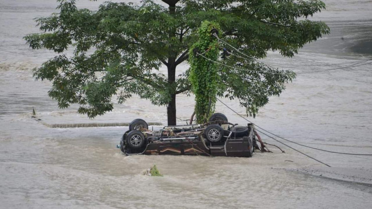
Video from the north of the state shows a muddy deluge rapidly overflowing the river, and flooded houses caked in dirt and debris, while images show search teams using excavators to uncover army vehicles buried deep in the mud.
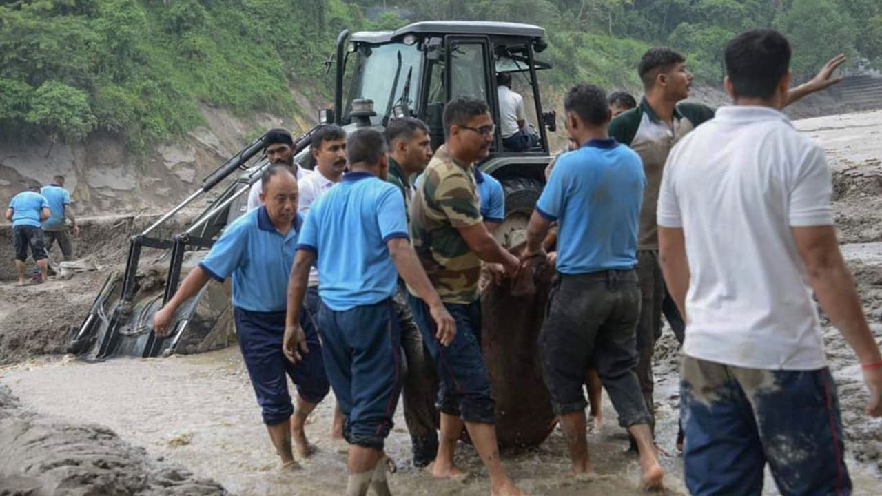
Rescue and restorations operations are underway with both state and national disaster personnel involved, the government said.
Known as the rooftop of the world, the ecologically-sensitive Himalayan region is prone to flash floods and landslides, and flooding is not unusual in Sikkim.
But scientists are clear that extreme weather is becoming more frequent and more intense as the human-caused climate crisis accelerates.
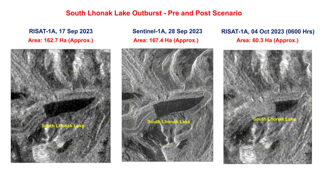
As search efforts continued Wednesday, the Indian Space Research Organization (ISRO) released dramatic images showing the volume of water which had been released from Lhonak Lake following the cloudburst.
Lhonak Lake is a large glacial bullet-shaped water body that sits at the foot of a melting glacier.
An analysis of the images shows more than 60% of the water held in the lake drained out after the extreme rainstorm triggered a glacial lake outburst. This phenomenon happens when a glacial lake rises too high or the surrounding land or ice gives way and the lake bursts, sending water and debris rushing down mountains.
One satellite image shows the lake holding about 167.4 hectares of water on September 28, while another dated October 4 shows the lake reduced by more than half – holding approximately 60.3 hectares of water in it.
“It is observed that lake is burst and about 105 hectares area has been drained out … which might have created a flash flood downstream (in the Teesta River),” ISRO said in text accompanying the images.
Scientists have long studied Lhonak Lake, identifying it as one of the fastest swelling glacial lakes in the region with a high risk for a potential glacial outburst, according to multiple studies.
In recent years, the state’s Disaster Management Authority led several expeditions to the site, concluding that a glacial lake outburst would “cause huge devastation downstream” and that “loss of life and property” were likely. Pipelines were installed at the lake to siphon off the water as a short-term solution.
And last May, the state government held a consultation workshop on such a risk, with the director of Sikkim’s Department of Science and Technology highlighting the “urgent need for an early warning system for these glacial lakes in Sikkim.”
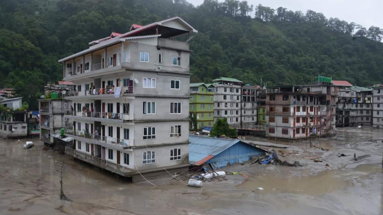
The Sikkim city of Pakyong was the worst affected with seven people killed in the floods and 59 people missing, the Sikkim government said.
Among those unaccounted for are dozens of members of the Indian Army. A “massive” search and rescue operation to find the missing soldiers has been launched but efforts were hampered by “incessant rains” and flooding that had cut off roads and washed-out bridges, the army said.
On Wednesday evening, one soldier was rescued and is in a stable condition but 22 others remain missing, according to the army.
At least 11 bridges collapsed in the flooding, impeding rescue efforts and cutting off remote areas, the government said.
In the state capital and largest city Gangtok, three deaths were reported and 22 people missing, it added.
More than 2,000 people have been evacuated and relief camps have been set up across the state to help more than 22,000 people affected by the flash floods.
On Thursday, the state government said at least 3,000 tourists remain stranded in Sikkim’s Lachung and Lachen and that helicopters are being deployed to help evacuate them.
The Teesta-V Hydropower Station was reported to be “under shutdown presently and not generating electricity,” the All India Radio (AIR) News reported, citing the country’s Power Ministry.
“All the bridges downstream to Teesta-V Hydropower Station up to Tarkhola and Pamphok have been submerged which has severely affected commutation and communication in these areas,” it said.
A “detailed assessment” of damage to the hydropower projects would be made by the central government once the flood water recedes, AIR News reported.
The India Meteorological Department has forecast heavy rainfall to continue across the country’s east and northeast, including Sikkim, for the next two days.
Sikkim’s chief minister Prem Singh Tamang said in a post on X, formerly Twitter, that emergency services have been mobilized to the affected areas, and he has “visited Singtam to assess the damages and engage with the local community.” Singtam is a town affected by the flooding about 30 kilometers (18 miles) from Gangtok.
Indian Prime Minister Narendra Modi called the situation an “unfortunate natural calamity” and offered “all possible support in addressing the challenge.”
“I pray for the safety and well-being of all those affected,” he wrote on X.
The Himalayan region is highly vulnerable to the climate crisis.
Himalayan glaciers feed into rivers that provide freshwater to two billion people and many communities depend on the glacial waters to irrigate their crops.
But a recent report warned the glaciers could lose up to 80% of their ice by 2100 as temperatures rise, heightening the likelihood of floods, landslides, avalanches and also drought.
As glaciers around the world melt at an alarming rate, about 15 million people who live near glacial lakes are at risk from catastrophic glacial lake outbursts, with more than half concentrated in just four countries – India, Pakistan, Peru and China – according to a study earlier this year.
These lake bursts have been compared to an “inland tsunami” and their impact akin to a sudden dam collapse, experts previously told CNN.
The ensuing floods happen with little to no warning and previous glacial lake outbursts have killed thousands of people and destroyed property and critical infrastructure.
A 2020 study of the Teesta River basin by scientists from the Indian Institute of Technology Guwahati, found a increase in rainfall and temperatures this century and that Sikkim’s many glacial lakes are expanding due to glacier and snow melt as temperatures rise.
The researchers warned that heavy rainfall events can cause the sudden expansion of lakes, risking glacial outburst floods, and it was “critical” that state disaster management departments are properly equipped to respond to such disasters and that policy makers implement climate change adaptation strategies.
In 2021, a Himalayan glacier collapsed in Uttarakhand, sending an avalanche of water, dust and rocks down a mountain gorge, and crashing though two hydroelectric projects, killing at least 38 people.
In India’s north, communities have warned for decades about unregulated commercial development, deforestation and back-to-back dam building in the fragile region, increasing the risk of disasters, flooding and landslides.
Sumber: www.cnn.com


